Surrey City Centre / Whalley — A Buyer’s Guide
A note from me: I’m Bronson Job, a REALTOR® (PREC) with Royal LePage Ben Gauer & Associates, so I earn a commission when I help someone buy or sell. I write these guides to be genuinely useful — general information, not advice on your specific situation — and I take no payment from any third party named in them. How I verify.
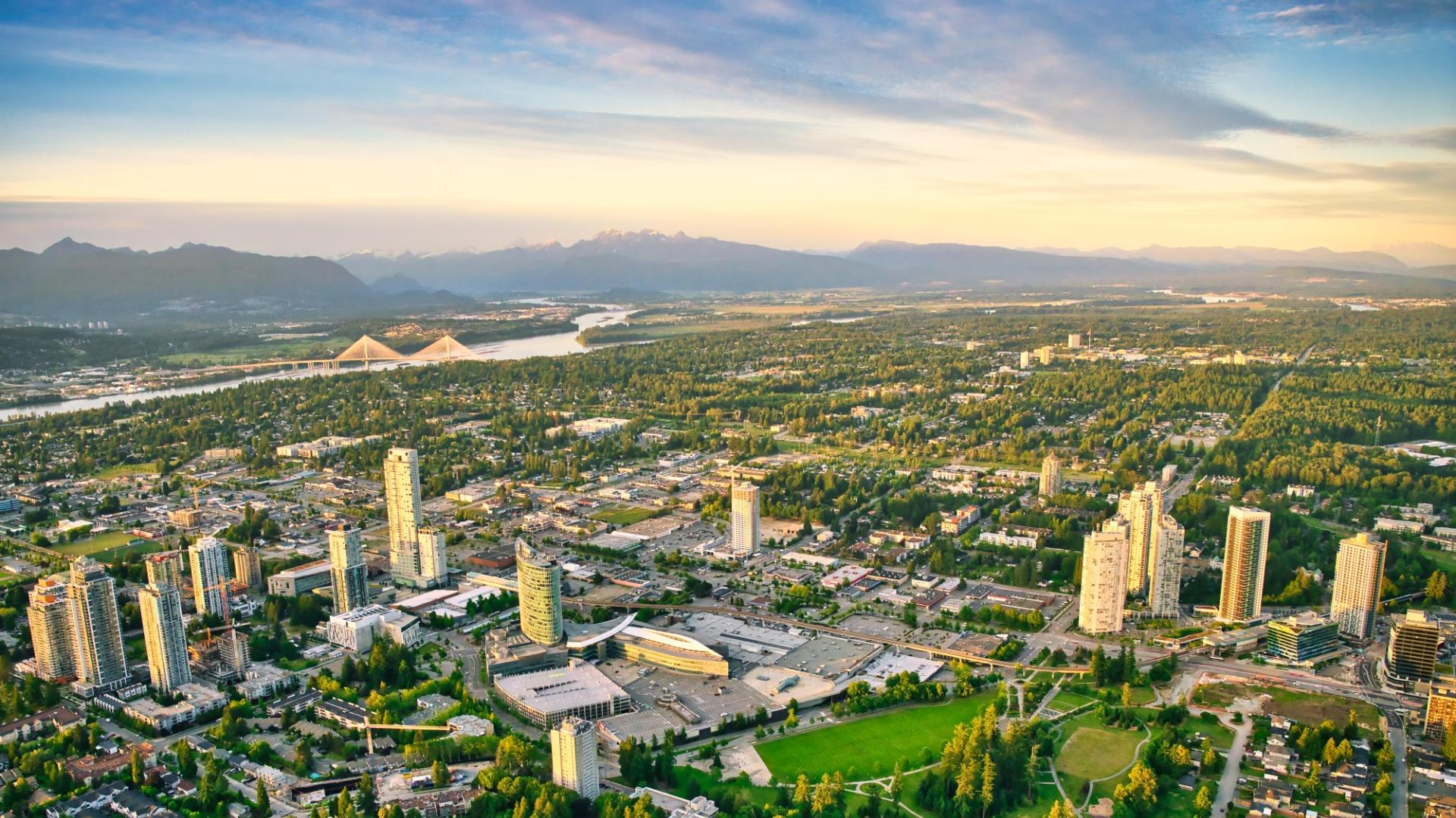
Surrey City Centre — long known by the older name Whalley — is the principal urban centre of the City of Surrey, a high-density downtown core with three Expo Line SkyTrain stations inside its planning boundary, the Simon Fraser University (SFU) Surrey + Kwantlen Polytechnic University (KPU) + Surrey Memorial Hospital + Central City Mall institutional cluster, and the western anchor of the future Surrey-Langley SkyTrain extension running east into Langley. This guide walks the City Centre block by block: the five sub-areas, the schools, the transit, the major redevelopments, and the tax math for presale condo buyers. It pairs with the Surrey area page and the Surrey-Langley SkyTrain corridor primer.
What Surrey City Centre offers
The Surrey City Centre case is built on three Expo Line stations inside the planning boundary, the SFU + KPU + Surrey Memorial Hospital institutional cluster, and the future Surrey-Langley SkyTrain interchange at King George. Buyers pay for transit access and a downtown-density urban core that no other Lower Mainland suburb offers at this scale.
What buyers should understand before pricing the corridor premium: the inventory mix is heavily weighted to high-rise concrete (with materially higher strata fees than wood-frame averages), the historic Whalley core retains visible social-services character around the station radii, and the area carries the deepest pre-sale and assignment inventory in Metro Vancouver. The corridor thesis compounds through the late-2029 SkyTrain opening; the day-to-day liveability is its own decision.
Market snapshot · May 2026
Surrey City Centre · HPI Benchmark
Benchmark price
$439K
Month over month
-2.3%
Year over year
-12.6%
Sales (month)
50
Active listings
680
Months of inventory
11.7
Fraser Valley Real Estate Board / Greater Vancouver REALTORS composite Home Price Index (HPI) — the industry-standard measure of typical home value, adjusted for property mix. Soft supply (buyers’ territory).
See the Surrey City Centre HPI chart on Market Insights
Source: Fraser Valley Real Estate Board · Real Estate Board of Greater Vancouver. Composite (all property types). HPI benchmarks are aggregate measures — specific properties may transact above or below.
Inside Surrey City Centre
Surrey City Centre is five named pieces, each at its own walking distance to a SkyTrain station and each with its own character. The Surrey Central Station core is the institutional and retail heart; the King George Hub is the southern anchor and the future SkyTrain interchange; the Whalley historic core retains older single-family stock; the 104 Avenue corridor is the east-west spine; and Bridgeview sits south of the City Centre boundary, frequently lumped in by postal proximity.
Surrey Central Station core
The Surrey Central Station core is the institutional and retail heart of Surrey City Centre, organised around the SkyTrain station opened in 1994 as part of the Surrey City Centre extension of the Expo Line (Scott Road station, the first crossing into Surrey, opened in 1990). The block contains Central City Mall (formerly Surrey Place), the Bing Thom-designed Central City tower housing SFU Surrey campus, Kwantlen Polytechnic University's Surrey campus, and direct pedestrian connections to Holland Park. Condo product is dominated by 2010s-and-newer concrete high-rise inventory transacting across a wide band depending on tower, floor, and finish — the live FVREB benchmark for Surrey City Centre apartment product moves with the market and should be pulled fresh at offer time.
King George Hub
The King George Hub sits at the southeast anchor of Surrey City Centre, organised around King George SkyTrain Station (opened 1994 as the original eastern terminus of the Expo Line extension) and the PCI Developments master-planned redevelopment of the former King George Station bus loop and surrounding parcels into a multi-tower mixed-use precinct (with Concord Pacific's Park George towers adjacent). The Hub is also the planned western terminus / interchange for the Surrey-Langley SkyTrain extension (late-2029 target) — meaning King George stops being an eastern terminus and becomes the western anchor of a Fraser Highway corridor running east into Langley. The corridor math is the most consequential part of the King George Hub thesis.
Whalley historic core (north of Fraser Hwy)
Whalley is the historical name for the neighbourhood immediately north of Fraser Highway and east of King George Boulevard, predating the City's rebranding of the broader area as Surrey City Centre. The historic core retains older single-family and small-scale multifamily stock alongside a wave of newer high-rise construction, and historically carried Surrey's working-class demographic identity. Gentrification is moving fast through the corridor blocks closest to Surrey Central and King George stations; further into the historic core, older inventory and Bill 44 SSMUH-eligible single-family lots remain. The neighbourhood's social-services infrastructure — including Front Room and other supports near 135A Street — is part of the day-to-day character buyers need to understand before pricing the corridor premium.
104 Avenue corridor
The 104 Avenue corridor runs east–west across the northern half of Surrey City Centre, transitioning from older mid-century stock to newer mid- and high-rise mixed-use product. The corridor is the spine connecting the Surrey Central Station core west toward 132 Street and the City Centre boundary, and is being repositioned through the Surrey City Centre Plan as a higher-density secondary spine alongside King George Boulevard. Day-to-day amenities and retail fall along this corridor; the corridor's Bill 47 Transit-Oriented Areas exposure is mediated by walking distance to Surrey Central, King George, and (for the eastern blocks) Gateway stations.
Bridgeview (north of City Centre)
Bridgeview sits north of Surrey City Centre, between the Fraser River and King George Boulevard, at the south end of the Pattullo Bridge corridor. It is a distinct neighbourhood with its own character — predominantly older single-family detached, smaller-scale industrial, and a meaningfully lower price point than the City Centre core. Bridgeview is *not* inside the Surrey City Centre Plan boundary but is frequently lumped into Surrey City Centre listings by virtue of postal proximity. Buyers comparing Bridgeview to Surrey City Centre proper need to understand they are pricing two different markets — Bridgeview is suburban-detached, Surrey City Centre is high-rise downtown. The new four-lane Stal̕əw̓asəm Bridge replacing the Pattullo opened February 14, 2026.
Schools — Kwantlen Park Secondary catchment
Surrey City Centre addresses generally feed Kwantlen Park Secondary School (grades 8–12), with Queen Elizabeth Secondary picking up the eastern edge. Elementary feeders include Hjorth Road Elementary, Old Yale Road Elementary, T.E. Scott Elementary, and A.J. McLellan Elementary depending on the specific block.
School District 36 (SD #36 / Surrey) is the largest school district in BC by enrolment — bigger than Vancouver and every other Lower Mainland district — and the District reviews catchment boundaries periodically. Verify the live SD #36 catchment map for the specific address before paying a school-catchment premium.
SD #36 also operates a robust French Immersion stream and several traditional / fine-arts / mini-school choice programs that are application-based, not pure catchment — families relying on a specific program need to confirm the application timeline and current eligibility before treating it as guaranteed. The post-secondary cluster within Surrey City Centre (SFU Surrey + Kwantlen Polytechnic University main campus) makes the City Centre an unusually education-anchored urban core for a Lower Mainland suburb.
Three Expo Line SkyTrain stations
Surrey City Centre is the only Lower Mainland urban centre with three Expo Line SkyTrain stations inside its planning boundary: Surrey Central Station, Gateway Station, and King George Station — all opened together on March 28, 1994 as the Surrey City Centre extension of the Expo Line. (Scott Road, the first crossing into Surrey, opened in 1990.) From Surrey Central, downtown Vancouver (Waterfront Station) is roughly 35–40 minutes during the day — direct, no transfer required.
The Surrey-Langley SkyTrain extension (under construction, late-2029 target per Province of BC + TransLink) extends the Expo Line east from King George Station along Fraser Highway through Fleetwood, Bakerview-166 St, Hillcrest-184 St, Clayton, Willowbrook, and a new terminus at Langley City Centre. That re-orients every existing Surrey City Centre tower comp: King George stops being an eastern terminus and becomes the western anchor of a longer Fraser Valley corridor. Construction is underway across all extension stations as of H1 2026.
Per BC TOD literature, properties within a walkable 800-metre radius of stations typically experience price appreciation premiums of 10–20%. Surrey City Centre uniquely contains three overlapping 800-metre radii — Surrey Central, King George, and Gateway — meaning the meaningful share of the City Centre planning area sits inside at least one TOD radius. The corridor premium typically lands within roughly 12 months of station opening; for Surrey City Centre, the relevant compounding is the Langley-corridor opening in late 2029.
The institutional cluster, in 2 sentences
SFU Surrey campus (housed in the Bing Thom-designed Central City tower above the mall), Kwantlen Polytechnic University’s main campus, Surrey Memorial Hospital (Fraser Health), and Central City Mall are all clustered around Surrey Central Station — making the City Centre an unusually education-and-healthcare-anchored urban core for a Lower Mainland suburb.
For buyers, the cluster matters in two ways: it creates a permanent rental demand floor (students + healthcare workers) that supports investor exit math, and it gives the day-to-day character of the City Centre core a different texture than a pure-commuter suburban downtown.
Major redevelopments — King George Hub, 3 Civic Plaza, Park Place
Three master-planned redevelopments shape the current Surrey City Centre tower inventory and the under-construction pipeline:
- King George Hub — PCI Developments master-planned mixed-use precinct on the former King George Station bus loop and surrounding parcels at the southeast anchor of the City Centre core. Multiple residential towers, retail, and office in phased build-out around the future Surrey-Langley SkyTrain interchange. (Concord Pacific’s adjacent Park George towers are a separate development on the same block.)
- 3 Civic Plaza by Century Group (ZGF Architects) — mixed-use tower co-located with a Marriott Autograph Collection hotel (Civic Hotel) in the same envelope, immediately adjacent to Surrey City Hall and Holland Park.
- Park Place by Concord Pacific — three-tower high-rise residential development at the King George Station corner, part of the post-2017 wave of concrete high-rise product.
- Central City tower — the Bing Thom-designed mixed-use complex housing SFU Surrey above Central City Mall (formerly Surrey Place), a defining piece of architecture in the City Centre.
Multiple additional towers are under construction or proposed across the Surrey City Centre Plan area as of 2026. The pipeline is one of the deepest in Metro Vancouver, which has implications both ways: for buyers, more selection and more pre-sale inventory; for investors, more competition for resale liquidity.
Bill 47 Transit-Oriented Areas tiers — three station radii
BC’s Bill 47 (the Transit-Oriented Areas Act, in force 2024) requires municipalities to allow specified densities in tiered radii around designated transit stations. The framework is layered — Tier 1 typically covers parcels within ~200 metres of a station (highest density / highest FAR / tallest height eligibility), Tier 2 covers ~400 metres (mid-density), and Tier 3 covers ~800 metres (lowest of the three but still above baseline single-family zoning). The exact density and height entitlements vary by station class and by municipal designation.
For Surrey City Centre specifically: three Expo Line stations all sit inside the planning boundary — Surrey Central, King George, and Gateway — meaning the Bill 47 tier radii overlap and stack. A meaningful share of the Surrey City Centre Plan area falls inside at least one Tier 3 (~800 m) ring, with the densest stacking around the Surrey Central + King George corridor. The Surrey City Centre Plan (originally adopted 2017, with subsequent amendments) was already targeting high-density buildout (80,000+ residents at full buildout) before Bill 47 came into force; the legislation is now layered on top of that planning entitlement.
Verify the current Bill 47 designation against the live Province TOD page and the City of Surrey zoning layer for the specific parcel before pricing any redevelopment optionality — the legislation is still being operationalised at the municipal level. See the cross-link to /glossary/transit-oriented-development-areas for the glossary entry and the /guides/transit-oriented-development-bc deep-dive guide.
Indo-Canadian cultural anchor
Surrey carries Canada’s largest South Asian population in raw numbers (~213,000 / 37.8% of the city, per Statistics Canada Census 2021) — and Surrey City Centre, alongside Newton and Cloverdale, is one of the cultural anchors. Practically, that means Punjabi-language signage and services across day-to-day retail, a dense network of South Asian–owned restaurants and grocery stores along the King George Boulevard and 104 Avenue corridors, and the Diwali / Vaisakhi celebrations that bring meaningful foot traffic and community presence to the corridor each year.
The Filipino, Chinese, and Korean communities also have a meaningful presence in and around the City Centre. The student demographic from KPU and SFU Surrey adds further mix to the corridor. Surrey City Centre is genuinely one of the most ethnically diverse urban centres in BC — this is part of the day-to-day liveability character that buyers should understand when comparing it against other Lower Mainland downtowns.
Notable amenities — Holland Park, Surrey Central Library, Civic Plaza
Holland Park is Surrey’s central park — a meaningful piece of urban open space that anchors the City Centre’s public realm and hosts the Surrey Fusion Festival each summer. Surrey Central Library at 10350 University Drive (designed by Bing Thom Architects, opened 2011) is one of the architecturally distinctive public buildings in BC, and serves as a community anchor across all demographics. Civic Plaza — the public plaza adjacent to Surrey City Hall and Century Group’s 3 Civic Plaza tower — is the City Centre’s primary outdoor civic gathering space.
Central City Mall (the retail anchor at Surrey Central Station, formerly Surrey Place) carries a full retail mix and is connected directly into the SFU Surrey campus through the Bing Thom tower above. Surrey Memorial Hospital (Fraser Health) is the regional hospital serving Surrey, North Delta, and parts of Langley — a major employment anchor that supports the rental demand floor for the City Centre.
Property mix — high-rise dominant
Surrey City Centre’s inventory mix is heavily weighted to high-rise and mid-rise condo product — the Surrey City Centre Plan (2017) targets 80,000+ residents at full buildout, and the bulk of the planning entitlement is for tower and mixed-use development around the three SkyTrain stations. Detached inventory persists primarily in the Whalley historic core north of Fraser Highway and along the eastern edge approaching 144 Street, and increasingly falls under Bill 44 SSMUH (Small-Scale Multi-Unit Housing) eligibility for up to four units.
Surrey City Centre falls inside the Greater Vancouver REALTORS (GVR / formerly REBGV) Whalley sub-area. The live HPI benchmark for apartment / condo product moves with the market and should be pulled fresh at offer time. Newer concrete high-rise product (3 Civic Plaza, Park Place, King George Hub) commands a meaningful premium over older 1990s–2000s wood-frame and earlier concrete inventory. Strata fees on newer concrete high-rises with hotel-style amenities can be materially higher than wood-frame averages — that line item changes the affordability math.
Surrey City Centre 2-bed concrete condo at $700K
Walk through the closing-day math — PTT, exemptions, GST, and the all-in number
Setup
2-bedroom 850 sq ft concrete high-rise condo, Surrey City Centre core, ~400 m walking distance to Surrey Central Station. Purchase price: $700,000. Down payment: 20% = $140,000. Financed: $560,000.
Property Transfer Tax (no exemptions)
Base PTT (BC bracket schedule): 1% × $200,000 + 2% × $500,000 = $2,000 + $10,000 = $12,000. Run the live numbers through the PTT calculator for the specific scenario.
First-Time Home Buyer (FTHB) exemption
The FTHB exemption is threshold-limited and may apply (in full or partially) at this purchase price depending on the live thresholds and the buyer’s eligibility. Confirm the current threshold against the BC government Property Transfer Tax page before underwriting it into the offer math.
Newly Built Home exemption (presale or new-build path)
The Newly Built Home exemption applies to qualifying new-construction purchases up to specified thresholds — full below a lower threshold, partial above, zero past the upper. At $700K a partial exemption is plausible and a full exemption may apply depending on the current structure. On a presale purchase the exemption is calculated at completion using the rules in force then, not at contract date.
GST + closing-day cash
GST (5%) applies on new construction; the new housing rebate phases out between $350K and $450K, so at $700K the rebate is zero. Down payment + PTT + GST + legal + adjustments + strata fee adjustments is the all-in number that rarely shows in the listing math. Run a complete number through the closing-day cash calculator.
Bylaws + zoning context
City of Surrey Official Community Plan, Surrey City Centre Plan, BC Bill 47 TOD overlay, and Bill 44 SSMUH
Surrey City Centre is governed by the City of Surrey’s Official Community Plan (OCP) plus the Surrey City Centre Plan (originally adopted by Council in 2017, with subsequent amendments) — the plan that designates the area as Surrey’s downtown and targets ~85,000 residents over the coming decades (with full-buildout capacity higher). The bulk of the planning entitlement is concentrated around the three SkyTrain stations as high-density Comprehensive Development (CD) zoning.
BC Bill 47 (Transit-Oriented Areas Act, in force 2024) overlays additional tiered density entitlements within ~200 m / ~400 m / ~800 m radii of Surrey Central, King George, and Gateway stations. Cross-streets transitioning between the high-density CD core and surrounding single-family neighbourhoods sit in mid-density RM-3 / RM-4 designations. Pull the current City of Surrey zoning layer and the Province’s TOD designation map for the specific parcel before pricing redevelopment optionality.
Bill 44 (Small-Scale Multi-Unit Housing, in force 2024) applies to single-family and duplex parcels outside the Bill 47 TOD radii — including a meaningful share of the Whalley historic core and the eastern edge of the City Centre. SSMUH-2 / SSMUH-3 / SSMUH-4 entitlements depend on lot size and servicing capacity. The Bill 47 TOD framework typically supersedes baseline SSMUH for parcels along King George Boulevard / Fraser Highway and within the station radii. See the Bill 44 / SSMUH guide for the deeper provincial-framework explainer.
Frequently asked questions
What schools are in the Surrey City Centre catchment?
Surrey City Centre addresses generally feed Kwantlen Park Secondary School (grades 8–12), with Queen Elizabeth Secondary picking up the eastern edge. Elementary feeders include Hjorth Road, Old Yale Road, T.E. Scott, and A.J. McLellan depending on the block. School District 36 (SD #36 / Surrey) is BC's largest district by enrolment and revises catchment boundaries periodically — verify the live SD #36 catchment map for the specific address before paying any school-catchment premium. Choice / French Immersion / fine-arts programs are application-based, not pure catchment.Is Whalley the same as Surrey City Centre?
Whalley is the historical neighbourhood name; Surrey City Centre is the City of Surrey's current branding. The Surrey City Centre Plan (2017, amended) covers roughly 108 Avenue (north) to Fraser Highway / 96 Avenue (south) and 132 Street (west) to 144 Street (east). The Whalley name persists in everyday use — particularly for the historic core north of Fraser Highway — and on FVREB micro-area listings. Functionally a listing referencing either name covers the same broad geography.How does the Surrey-Langley SkyTrain extension affect Surrey City Centre?
The Surrey-Langley SkyTrain extension (under construction, late-2029 target per Province of BC and TransLink) extends the Expo Line east from King George Station along Fraser Highway through Fleetwood, Clayton, and Willowbrook to a new terminus at Langley City Centre. King George is the western anchor / interchange of that extension, not a station along it — Surrey City Centre stops being the eastern terminus and becomes the western anchor of a longer Fraser Valley corridor. The Province has revised the in-service target before, so confirm the published date before pricing the corridor effect into an offer.What's the typical Surrey City Centre condo price in 2026?
Surrey City Centre condos transact across a wide band depending on tower, floor, view, and finish. Pull the live REBGV / GVR apartment benchmark for Whalley at offer time. Newer concrete towers (3 Civic Plaza, Park Place, King George Hub) sit at a meaningful premium over 1990s–2000s wood-frame and earlier concrete. Strata fees on newer concrete high-rises with hotel-style amenities can be materially higher than wood-frame averages — that line item changes the affordability math.Are there detached homes in Surrey City Centre?
Some — but inventory is heavily weighted to high- and mid-rise condo. The Surrey City Centre Plan (2017) targets 80,000+ residents at full buildout via high-density redevelopment, mostly around the three SkyTrain stations. Detached inventory persists in the Whalley historic core north of Fraser Highway and along the eastern edge toward 144 Street, and increasingly falls under Bill 44 Small-Scale Multi-Unit Housing (SSMUH) eligibility or Bill 47 Transit-Oriented Areas density. For a single-family lot in Surrey, look to South Surrey, Cloverdale, or eastern Newton — not the City Centre.Is Surrey City Centre a good investment?
It depends on holding period, leverage, and the buyer's objective. Bull case: three Expo Line stations + SFU Surrey + KPU + Surrey Memorial Hospital + Central City Mall + the Surrey-Langley SkyTrain extension making King George the western anchor of a Fraser Highway corridor into Langley by late 2029. Bear case: the highest concentration of pre-sale and assignment inventory in Metro Vancouver, materially higher concrete-tower strata fees, street-level liveability around the historic core, and presale-assignment investors facing BC Home Flipping Tax (effective Jan 1, 2025) plus the federal anti-flipping rule. Model both before pricing the corridor effect into an offer.What's the commute to downtown Vancouver from Surrey City Centre?
From Surrey Central Station, Waterfront Station (downtown Vancouver) is roughly 35–40 minutes on the Expo Line — direct, no transfer. King George and Gateway stations add a stop or two. By car at peak: typically 50–80 minutes via Highway 99 / Oak Street Bridge or Highway 1 / Port Mann depending on time of day. Once the Surrey-Langley extension opens (late-2029 target), Surrey City Centre becomes a regional interchange — riders board or transfer at Surrey Central / King George from Langley, Fleetwood, and Clayton.How does the Indo-Canadian cultural anchor affect liveability?
Surrey carries Canada's largest South Asian population in raw numbers — ~213,000 residents, 37.8% of the city, per Statistics Canada Census 2021. Surrey City Centre, alongside Newton and Cloverdale, is one of the cultural anchors — Punjabi signage and services in day-to-day retail, a dense network of South Asian–owned restaurants and grocers along King George Boulevard and 104 Avenue, and the Diwali / Vaisakhi celebrations that bring meaningful foot traffic each year. Filipino, Chinese, and Korean communities also have a meaningful presence. The KPU + SFU Surrey student demographic adds further mix to the corridor.Does the Newly Built Home exemption apply to Surrey City Centre presales?
Depends on the price at completion and buyer eligibility. The BC Newly Built Home PTT exemption applies to qualifying new-construction up to specified thresholds — full exemption below a lower threshold, partial above, zero past the upper. Many 1- and 2-bedroom Surrey City Centre presales at completion will qualify for some relief; larger 2-bed-plus-den or 3-bed presales may sit above the ceiling. Thresholds change — verify against the BC government PTT page before underwriting. GST (5%) also applies on new construction; the new housing rebate phases out between $350K and $450K.
What to read next
- · Surrey City Centre REALTOR® — working with Bronson Job on a Surrey City Centre purchase or sale
- · Surrey-Langley SkyTrain corridor primer — the 16 km, 8-station extension making Surrey City Centre the western anchor
- · Yorkson (Willoughby) — the eastern anchor of the same Fraser Highway corridor
- · Willoughby — the broader Willoughby buyer’s guide
- · BC Transit-Oriented Development Areas — the Bill 47 framework + 800-metre TOD radius
- · Transit-Oriented Development Areas glossary — the one-paragraph definition + Fact Bank cite
- · Newly Built Home exemption glossary — the PTT exemption that often applies to new-construction presales
- · BC Property Transfer Tax — the bracket schedule + worked examples
- · Bill 44 / SSMUH guide — the small-scale multi-unit framework for Whalley historic-core lots
- · Closing-day cash calculator — the all-in number for a Surrey City Centre presale condo purchase
- · BC affordability calculator — model the qualifying rate against a Surrey City Centre target
- · Surrey area page — the city-wide context for the City Centre
- · BC Real Estate Codex — primary-source-cited reference for every fact above
Verified sources (3)· re-verified 2026-05-09Click to expand
Every claim on this page is sourced to a primary government, regulator, or industry-association URL. We re-verify quarterly; the verification dates below show when each source was last confirmed against the live government page.
- BC Governmentretrieved 2026-05-09Bill 47 — Housing Statutes (Transit-Oriented Areas) Amendment Act, 2023https://www.bclaws.gov.bc.ca/civix/document/id/lc/billscur/4th42nd:gov47-3
- BC Governmentretrieved 2026-05-09Transit-Oriented Development Areas — Province of British Columbiahttps://www2.gov.bc.ca/gov/content/housing-tenancy/local-governments-and-housing/housing-initiatives/transit-oriented-development-areas
- BC Governmentretrieved 2026-05-09· published 2023-11-08New legislation requires homes near transithttps://news.gov.bc.ca/releases/2023HOUS0153-001706
bc.tod.transit_oriented_development · v1View in Codex →Verified sources (2)· re-verified 2026-05-08Click to expand
Every claim on this page is sourced to a primary government, regulator, or industry-association URL. We re-verify quarterly; the verification dates below show when each source was last confirmed against the live government page.
- BC Governmentretrieved 2026-05-08Small-scale multi-unit housing (SSMUH)https://www2.gov.bc.ca/gov/content/housing-tenancy/local-governments-and-housing/housing-initiatives/smale-scale-multi-unit-housing
- Otherretrieved 2026-05-08Township of Langley — Zoning and Bylaws (Bylaw 6020)https://www.tol.ca/en/services/zoning-and-bylaws.aspx
bc.bill44_2023_ssmuh · v1View in Codex →